
HistoryShift
HistoryShift
What Is a Batholith?
A batholith (from Ancient Greek βαθύς (bathús), meaning "deep", and λίθος (líthos), meaning "stone") is a large mass of intrusive igneous rock (also called plutonic rock), larger than 100 km2 (40 sq mi) in area,[1] that forms from cooled magma deep in the Earth's crust. Batholiths are almost always made mostly of felsic or intermediate rock types, such as granite, quartz monzonite, or diorite.
Formation
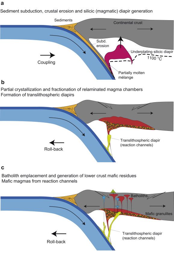
Although they may appear uniform, batholiths are in fact structures with complex histories and compositions. They are composed of multiple masses, or plutons, bodies of igneous rock of irregular dimensions (typically at least several kilometers) that can be distinguished from adjacent igneous rock by some combination of criteria including age, composition, texture, or mappable structures. Individual plutons are solidified from magma that traveled toward the surface from a zone of partial melting near the base of the Earth's crust.
Traditionally, these plutons have been considered to form by ascent of relatively buoyant magma in large masses called plutonic diapirs. Because the diapirs are liquified and very hot, they tend to rise through the surrounding native country rock, pushing it aside and partially melting it. Most diapirs do not reach the surface to form volcanoes, but instead they slow down, cool, and usually solidify 5 to 30 kilometers underground as plutons (hence the use of the word pluton; in reference to the Roman god of the underworld Pluto). An alternate view is that plutons are formed by aggregation of smaller volumes of magma that ascend as dikes.[2]
A batholith is formed when many plutons converge to form a huge expanse of granitic rock. Some batholiths are mammoth, paralleling past and present subduction zones and other heat sources for hundreds of kilometers in continental crust. One such batholith is the Sierra Nevada Batholith, which is a continuous granitic formation that makes up much of the Sierra Nevada in California. An even larger batholith, the Coast Plutonic Complex, is found predominantly in the Coast Mountains of western Canada; it extends for 1,800 kilometers and reaches into southeastern Alaska.
Surface expression and erosion
A batholith is an exposed area of (mostly) continuous plutonic rock that covers an area larger than 100 square kilometers (40 square miles). Areas smaller than 100 square kilometers are called stocks.[3] However, the majority of batholiths visible at the surface (via outcroppings) have areas far greater than 100 square kilometers. These areas are exposed to the surface through the process of erosion accelerated by continental uplift acting over many tens of millions to hundreds of millions of years. This process has removed several tens of square kilometers of overlying rock in many areas, exposing the once deeply buried batholiths.
Batholiths exposed at the surface are subjected to huge pressure differences between their former location deep in the earth and their new location at or near the surface. As a result, their crystal structure expands slightly over time. This manifests itself by a form of mass wasting called exfoliation. This form of weathering causes convex and relatively thin sheets of rock to slough off the exposed surfaces of batholiths (a process accelerated by frost wedging). The result is fairly clean and rounded rock faces. A well-known result of this process is Half Dome in Yosemite Valley.
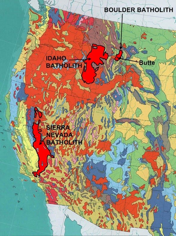
Boulder Batholith
The Boulder Batholith is a relatively small batholith in southwestern Montana, United States, exposed at the surface as granite (more specifically quartz monzonite) and serving as the host rock for rich mineralized deposits at Butte and other locations. The batholith lies roughly between Butte and Helena, and between the Deer Lodge (Upper Clark Fork) Valley and the Broadwater (Upper Missouri) Valley. The volcanic Elkhorn Mountains are a large mass of forested lava associated with the batholith.
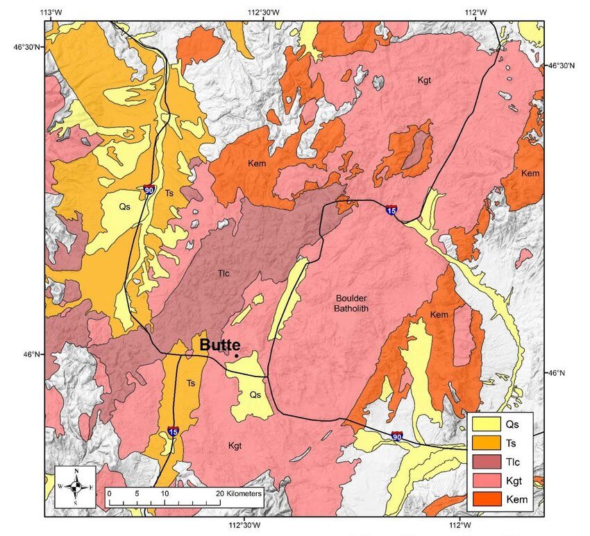
The batholith is composed of at least seven, and possibly as many as 14, discrete rock masses called plutons, which had formed beneath the Earth's surface during a period of magma intrusion about 73 to 78 million years ago (Late Cretaceous time).[1] The rising buoyant plutons resulted from subduction along what was then the west coast of North America, which was near today's border between Montana and Idaho. Regional uplift brought the deep-seated granite to the surface, where erosion exposed the rocks and the extremely rich mineral veins they contained. Hundreds of millions of dollars of copper, silver, gold, zinc, lead, and other metals have been mined from the batholith, both using underground mining and pit mining.
The Butte Granite makes up the bulk of the batholith (about 70%), with additional named intrusions along the periphery consisting of granodiorite, monzogranite, and minor syenogranite. The batholith intruded into Mesoproterozoic and Mesozoic sedimentary rocks, including the Elkhorn Mountains volcanics. The origin of these igneous rocks is related to subduction and continental magmatic arc processes associated with the Late Cretaceous western margin of North America. Later hydrothermal vein activity along fault and shear zones within the Butte quartz monzonite and its contact with adjacent rocks, resulted in major ore deposits of lead, zinc, and silver.[2][3]
The Boulder Batholith was named for the prominent rounded boulders that typify its landscape, the result of spheroidal weathering of fractured granite. It measures approximately 75 miles (121 km) north-south by about 25 miles (40 km) east-west, rather small in comparison to most batholiths.
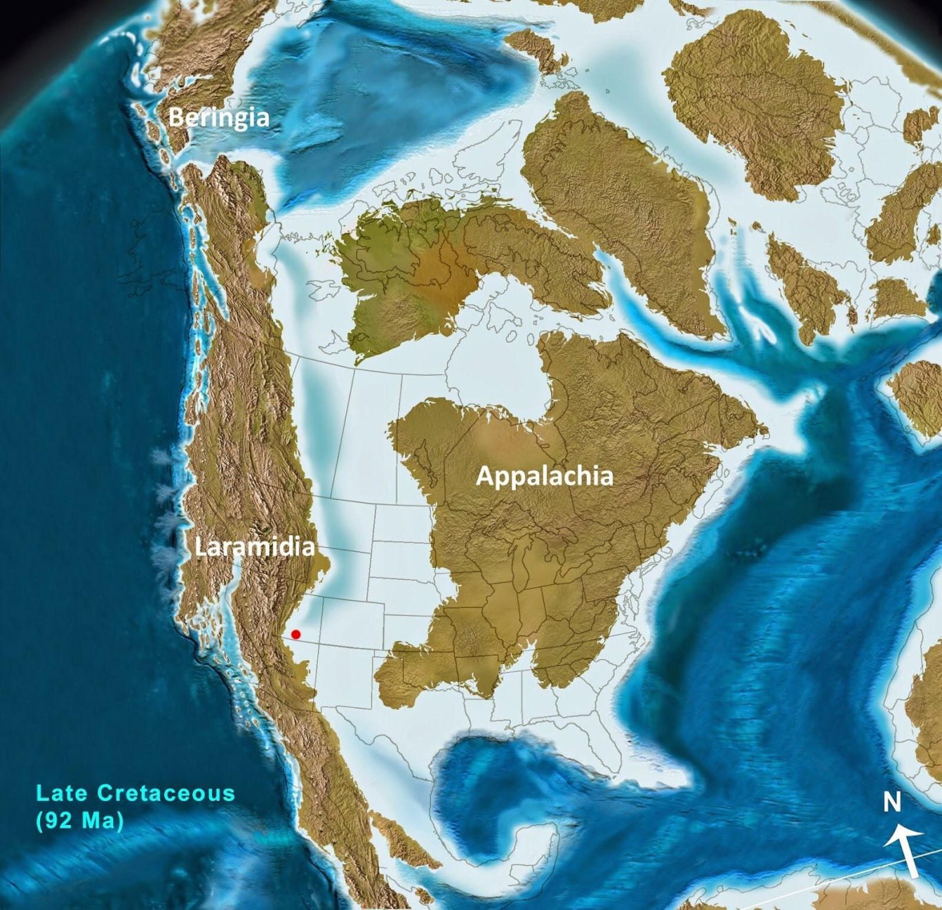
North America 78 Million Years Ago
Around 78 million years ago, during the Late Cretaceous, North America was divided into two landmasses—Laramidia (west) and Appalachia (east)—by the shallow Western Interior Seaway, which stretched from the Arctic Ocean to the Gulf of Mexico. The climate was warm and humid, with Laramidia acting as a, lush, swampy, and mountainous hotspot for dinosaur evolution, including early Tyrannosaurus relatives, hadrosaurs, and ceratopsians like Lokiceratops.
Key Geographical and Environmental Features:
Western Interior Seaway: This massive body of water divided the continent, covering the central United States and Canada. It was inhabited by marine reptiles such as mosasaurs and plesiosaurs, as well as sharks and ammonites.
Laramidia (Western Landmass): A narrow, mountainous island continent extending from Alaska to Mexico. It was characterized by rapidly forming mountains (the early Rockies) and coastal floodplains.
Appalachia (Eastern Landmass): The eastern, more stable landmass, which was separated from the west.
Climate: The environment was much warmer and more tropical than today, with thick forests, swamps, and no polar ice caps.
Flora and Fauna:
Dinosaurs: Laramidia was highly biodiverse. Known inhabitants from this specific era (approx. 78-77 Ma) include early tyrannosaurids, duck-billed hadrosaurs, and distinct ceratopsian species like Lokiceratops.
Vegetation: The landscape featured lush, green vegetation, including flowering plants (angiosperms) that were becoming more dominant.
Marine Life: The inland sea was full of life, including Platycarpus (a type of mosasaur) and giant fish.
This period represented a "hothouse" world, where sea levels were high and tectonic activity was intense, shaping the future geography of the continent.
We need your consent to load the translations
We use a third-party service to translate the website content that may collect data about your activity. Please review the details in the privacy policy and accept the service to view the translations.